Map of Greece: Understand the Islands, Mainland and Travel Routes
Author: Kenan Ungur
Article Date: 30.11.2024
Reading Time: 18 min

Map of Greece: Understand the Islands, Mainland and Travel Routes
Updated: August 2026

Greece looks wonderfully simple on a small map. Athens sits on the mainland, blue water spreads south and east, and hundreds of islands appear to invite an effortless journey from one to another.

Then you start planning.

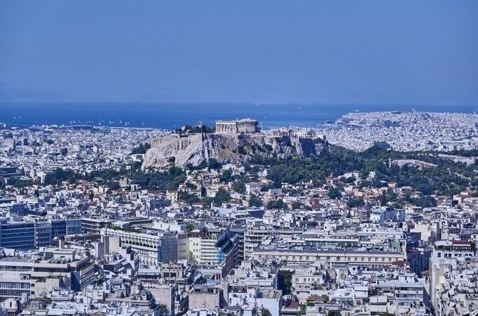
Santorini and Mykonos belong to the same famous island group, yet adding Crete changes the geographical scale of the trip. Rhodes lies far to the southeast and should not be treated as though it were simply the next Cycladic island. Corfu is on the opposite side of the country in the Ionian Sea, while Delphi and Meteora pull the journey inland rather than toward a ferry port. Even Athens needs to be understood correctly: the capital is an essential gateway, but its airport, city center and principal ferry ports occupy different parts of the wider metropolitan area.

This is why a useful map of Greece should do more than identify islands.

It should help you understand which destinations naturally belong together, when the sea creates an easy route, when it creates an inconvenient one, and when flying makes more geographical sense than continuing by ferry.

Greece rewards travelers who understand its shape before choosing their stops.

Greece Is Not One Mainland Surrounded by Interchangeable Islands

The first step is to stop thinking of “the Greek islands” as one geographical unit.

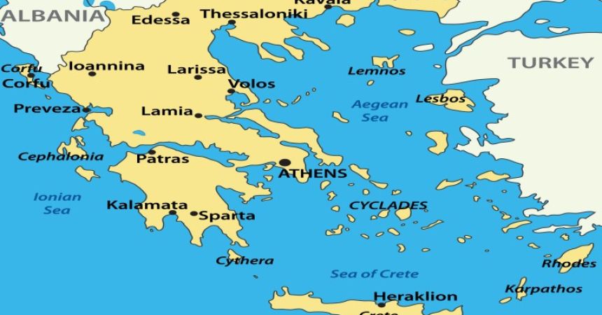
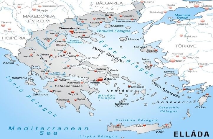
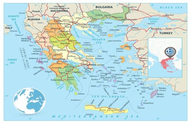
Greece has numerous island groups distributed across several seas, and those groups matter enormously when planning travel. The Cyclades occupy the central Aegean and include many of the islands international visitors know best. The Dodecanese stretch toward Turkey in the southeastern Aegean. The Ionian Islands lie west of mainland Greece. Crete forms a substantial southern world of its own, while the Saronic Islands sit much closer to Athens.

Mainland Greece adds another layer altogether.

Athens and the Peloponnese occupy southern mainland geography, while Delphi lies northwest of Athens and Meteora much farther inland toward central Greece. Thessaloniki anchors northern Greece and opens routes that have little to do with the classic Cycladic island circuit.

When all of this is compressed onto a single tourism map, the country can look smaller and more interconnected than the journey itself will feel.

The solution is not memorizing every island.

It is learning to see Greece in travel zones.

The Island Groups Are the Real Key to Reading a Greece Map

Island groups are more useful to a traveler than a random list of famous names because geography often influences transportation patterns.

Travel Zone Familiar Destinations Geographic Character What the Map Tells You
Athens & Attica Athens, Piraeus, Cape Sounion Mainland gateway Starting point for many routes
Cyclades Mykonos, Paros, Naxos, Santorini Central Aegean islands Strong island-hopping geography
Crete Heraklion, Chania, Rethymno Large southern island Deserves more time than a small-island stop
Dodecanese Rhodes, Kos, Patmos Southeastern Aegean Better treated as a separate island corridor
Ionian Islands Corfu, Zakynthos, Kefalonia West of mainland Geographically separate from Cyclades
Saronic Islands Hydra, Poros, Aegina Near Athens Suitable for shorter Athens-based sea journeys
Mainland Greece Delphi, Meteora, Peloponnese Road-oriented geography Requires different planning from island routes
Northern Greece Thessaloniki and surrounding regions Continental north Often forms its own journey

This is the foundation of Greece route planning.

Two destinations being Greek islands does not make them natural neighbors.

Athens Is a Gateway, but Greece Does Not Radiate Neatly From Athens

Athens dominates many first-time Greece itineraries, and for good reason. The country's principal international gateway is there, the Acropolis gives the journey an immediate historical anchor, and Piraeus provides access to numerous ferry routes.

Yet Athens should not be imagined as the center of a wheel to which every destination must repeatedly return.

Once a traveler moves into the Cyclades, for example, continuing between islands can be more logical than returning to Athens after each stop. Conversely, some combinations do require a return through Athens because a direct island connection may not suit the date, season or route.

The distinction matters.

A poorly designed island trip can contain unnecessary Athens transits that look harmless on paper but create repeated packing, port transfers and waiting. A well-designed one uses Athens where it performs a genuine gateway function and allows the island sequence to develop naturally afterward.

This is one reason our Athens and Greek Islands tours are structured around route progression rather than treating every island as an independent excursion from the capital.

Athens begins many Greek journeys.

It does not need to interrupt all of them.

The Cyclades Form Greece's Most Familiar Island-Hopping Geography

For many first-time visitors, the Greece map eventually becomes a Cyclades map.

Mykonos, Paros, Naxos and Santorini occupy the central and southern Aegean and can create a geographically coherent island-hopping journey. Their shared island group is one reason they appear together so frequently in travel planning.

However, even within the Cyclades, route design deserves more thought than drawing straight lines between dots.

Mykonos sits farther north than Santorini. Paros and Naxos occupy central positions that can fit naturally into a longer island sequence, while Santorini lies considerably farther south.

This geography means a route can often progress through the islands rather than jumping randomly between them.

It also explains why adding too many Cycladic islands does not automatically improve a holiday. Every island introduces another hotel departure, port transfer, ferry journey, arrival and check-in. Four geographically sensible islands can still create a poor trip if the available time is too short.

The map shows whether the sequence works.

The calendar decides whether you should actually do it.

Mykonos and Santorini Are a Pair, but They Are Not the Same Experience

On tourism maps, Mykonos and Santorini sometimes appear almost inseparable. Both are Cycladic islands, both connect naturally with Athens, and both feature prominently in first-time Greece travel.

Geographically, however, they occupy different positions within the Cyclades.

Mykonos is farther north and relatively well positioned for combinations involving central Cycladic islands. Santorini sits to the south, where the map begins pointing naturally toward Crete.

That geographical distinction creates useful route logic.

A traveler planning Athens, Mykonos and Santorini can move broadly southward through the Aegean rather than treating the islands as disconnected side trips. Add Crete and the route can continue farther south, provided the transportation pattern and available days support it.

This is the kind of information a map page should own.

What to do in Mykonos belongs to Mykonos content.

Why Mykonos belongs before or after another island is a geographical question.

Paros and Naxos Can Make an Island Route Feel More Continuous

Paros and Naxos occupy valuable positions within the Cyclades because they can connect the better-known northern and southern parts of an island-hopping journey.

That does not mean every traveler should include them.

Their geographical usefulness becomes most relevant when someone wants a longer island-focused trip rather than a quick Athens–Mykonos–Santorini introduction.

A route incorporating Mykonos, Paros, Naxos and Santorini can look remarkably satisfying on the map because there is a visible progression through the Cyclades. Operationally, however, the number of islands needs to match the available nights.

This is where map-based planning and itinerary planning should remain separate.

The map tells you that the islands belong naturally within the same geographical family.

It should not encourage you to squeeze all four into six days.

Geographic compatibility is permission to consider a combination, not an instruction to book it.

Santorini Is Where the Map Begins Pointing Toward Crete

Santorini's southern position within the Cyclades becomes particularly important when Crete enters the conversation.

Crete lies farther south and is much larger than the islands many visitors have just experienced. On a map, continuing from Santorini toward Crete can create a satisfying geographical progression rather than returning north immediately.

But Crete changes more than the direction of travel.

It changes scale.

Heraklion, Chania and Rethymno are not simply different neighborhoods of one compact resort island. Crete has enough geography, history, beaches, towns and mountain landscapes to support an entire trip of its own.

Treating it like another two-night Cycladic stop can therefore be misleading.

For travelers considering Cyclades and Crete travel packages, the important map lesson is that Crete can work as a southern continuation, but its size should influence how much time remains once you arrive.

A route can be geographically elegant and still be too fast.

Rhodes Belongs to a Different Aegean Story

Rhodes is one of the clearest examples of why Greece should not be planned from a list of famous islands.

Look southeast.

Rhodes lies in the Dodecanese, much closer to Turkey's southwestern coast than to Athens or the central Cyclades. Kos and other Dodecanese islands belong to the same broader southeastern geography.

This does not prevent travelers from combining Rhodes with Santorini, Athens or Crete.

It simply means those combinations should be evaluated through actual transportation rather than the assumption that all major Greek islands connect conveniently with one another.

A trip centered on Rhodes and the Dodecanese has its own geographical logic, just as a Cyclades journey does.

Trying to combine Corfu, Mykonos, Santorini and Rhodes because they are four famous Greek islands would create an entirely different logistical problem.

The map reveals that immediately.

Corfu Is on the Other Side of Greece

Corfu belongs to the Ionian Islands, west of mainland Greece.

That one fact should fundamentally change how you think about adding it to a Cyclades itinerary.

Mykonos and Santorini are in the Aegean to the east and southeast of the mainland. Corfu sits in the Ionian Sea on the opposite side of the country. The islands may share Greek history and Mediterranean character, but geographically they belong to different travel systems.

This does not mean they can never appear in the same holiday.

With sufficient time and appropriate flight connections, a multi-region Greece journey can deliberately combine them. What should be avoided is treating Corfu as though it were another ferry stop after Santorini.

This distinction also protects our destination clusters.

A Corfu guide should explain Corfu.

A Greece map should explain why reaching Corfu changes the structure of the trip.

The Saronic Islands Solve a Completely Different Travel Problem

Not every island experience requires flying deep into the Aegean or committing several nights to island hopping.

The Saronic Islands lie relatively close to Athens and include destinations such as Aegina, Poros and Hydra.

Their geographical value is therefore different.

For travelers with limited time, they can introduce an island dimension without constructing a full Cyclades route. This makes them especially relevant when Athens remains the principal base and the objective is to experience the sea rather than relocate repeatedly between hotels.

The map makes this distinction easy to understand.

Santorini may be more internationally famous, but it does not solve the same planning problem as a nearby Saronic island.

Distance changes purpose.

That is why “best Greek island” is often a less useful question than “best island for the route I already have.”

Mainland Greece Runs on Different Geography

Once Delphi and Meteora enter the itinerary, ferries stop being the organizing principle.

Delphi lies northwest of Athens on the mainland, while Meteora is considerably farther north in central Greece. A journey connecting them is fundamentally road-oriented and belongs to a different geographical pattern from island hopping.

This is important because first-time visitors sometimes attempt to alternate constantly between mainland and islands:

Athens, island, Athens, Delphi, Athens, another island.

The result can involve unnecessary transitions.

A more coherent route often groups mainland experiences together and island experiences together, then uses Athens or another appropriate gateway to connect the two sections.

The Peloponnese creates another mainland possibility, extending southwest from the Athens region and opening archaeological and scenic routes that can occupy several days without involving an island at all.

Greece is famous for its islands.

Its mainland still deserves its own map.


Explore Greece: Tourist Maps & Must-See Attractions

Meteora Is Farther From Athens Than the Map Makes It Feel

Meteora's monasteries are among Greece's most distinctive sights, but their location is important.

They sit near Kalambaka in central mainland Greece, substantially north of Athens. That means Meteora should not be treated like a short excursion added casually between an Athens morning and an island ferry.

The journey itself needs space.

Combining Delphi and Meteora can make geographical sense because both belong to the mainland section of a broader Greece journey, although the exact structure depends on available transportation and time.

This illustrates an important map principle:

distance is not a reason to exclude somewhere; it is a reason to give the journey the time it deserves.

When travelers ignore that distinction, excellent destinations become exhausting ones.

Ferries Follow Networks, Not the Straight Lines You Draw on a Map

Perhaps the most important operational lesson in Greek geography is that physical proximity does not guarantee convenient transportation.

Travelers often look at two islands, notice that they appear relatively close and assume there must be a direct ferry at a useful time.

That assumption should never form the foundation of the itinerary.

Greek ferry networks vary by route and season, and schedules can change. Major Cycladic combinations generally have stronger connections during the main tourism period, while less obvious island pairings may require different planning.

A map therefore answers only the first question:

Are these places geographically related?

The next question must be:

Does the transportation network connect them in a way that works for my dates?

Those are not the same thing.

This is also why an island itinerary should not be locked around an imagined ferry schedule months before the relevant transportation pattern is confirmed.

Geography suggests the route.

Operations validate it.

Sometimes a Flight Is More “Geographical” Than a Ferry

The romantic image of Greek travel is a ferry crossing blue water between whitewashed islands.

Sometimes the best route involves an aircraft.

If two destinations belong to different island groups or opposite sides of the country, insisting on traveling entirely by ferry can introduce unnecessary connections and consume substantial time.

Flights can also help when combining mainland gateways with larger islands such as Crete or Rhodes.

This does not make the journey less authentic.

Transportation should serve the geography rather than a preconceived idea of how Greece ought to be experienced.

A ferry is wonderful when it naturally continues the route.

A flight is wonderful when it gives you back half a day of your holiday.

Backtracking Through Athens Is Sometimes Necessary—and Sometimes a Warning

Returning to Athens is not automatically inefficient.

International flights, domestic air connections and ferry networks can make Athens the logical transfer point between geographically separate parts of Greece. A traveler moving from an Ionian destination toward the Cyclades, for example, may reasonably need a mainland or air connection.

The problem is unnecessary repetition.

If an itinerary repeatedly returns to Athens between islands that could have been organized into a continuous route, the map should trigger a second look.

Think of Athens as a gateway rather than a compulsory reset button.

Use it when transportation requires it, when you actually want more time in the city or when it connects two distinct sections of the journey.

Do not return simply because every destination was planned independently.
Greece Travel Map & Guide: Your Ultimate Companio

How We Read the Greece Map When Building a Journey

After years of arranging Greece travel, the most useful planning question is rarely “How many islands can we include?”

We look first at where the traveler enters Greece, where the journey should finish and what geographical direction connects the priorities between those points.

If Athens, Mykonos and Santorini are essential, the map already suggests a Cycladic progression. If Crete is added, the route extends farther south and the available days need to reflect that. If Rhodes replaces Crete, the journey shifts toward the southeastern Aegean. If Corfu becomes essential, we are no longer designing a pure Aegean route at all.

For customized Greece island-hopping tours, this is where genuine customization matters.

Changing a hotel does not fundamentally customize a trip.

Changing the geographical sequence so that the traveler spends more time enjoying Greece and less time repeatedly reaching it does.

The Best Greece Route Is Usually a Corridor, Not a Collection

A strong Greece journey often has a visible direction when you trace it on the map.

Athens can lead into the Cyclades.

Mykonos can lead toward central Cycladic islands and farther south toward Santorini.

Santorini can create a natural transition toward Crete when schedules and season support the connection.

A mainland route can move from Athens toward Delphi and Meteora without repeatedly returning to the capital between every stop.

A Dodecanese journey can develop around Rhodes and neighboring southeastern islands rather than borrowing its structure from a Cyclades itinerary.

None of these corridors is universally best.

The important point is that the destinations have a geographical relationship beyond simply being places you want to visit.

When every stop has a reason for following the previous one, Greece becomes remarkably fluid.

When every famous island is treated as equally close to every other famous island, the holiday begins accumulating ports, airports and waiting rooms.

Use the Map Before You Fall in Love With the Itinerary

Greece invites ambitious planning because so many places look irresistible.

The map provides useful discipline.

Choose the experiences that matter most, identify which geographical family they belong to and then see whether a natural travel corridor emerges. If three of your preferred islands are in the Cyclades and the fourth is Corfu, recognize that the fourth choice changes the structure significantly. If Meteora matters as much as Santorini, protect enough time for both the mainland and island sections instead of squeezing one between ferry days.

The objective is not to create the shortest route imaginable.

Some detours are worth taking precisely because the destination matters to you.

The objective is to understand the geographical price of every choice before paying for it with holiday time.

A good Greece map does not tell you where to go.

It helps you understand what happens to the journey when you decide to go there.

Frequently Asked Questions About the Map of Greece

1. Where is Greece located on the map of Europe?

Greece lies in southeastern Europe at the southern end of the Balkan Peninsula, with extensive coastlines along the Aegean, Ionian and Mediterranean seas. Its position helps explain both its large number of islands and its historical connections across the eastern Mediterranean.

2. Where is Athens on the map of Greece?

Athens lies in the Attica region of southern mainland Greece, facing the Aegean and relatively close to major ferry gateways including Piraeus. Its location makes it an important starting point for both mainland journeys and routes continuing into several Greek island groups.

3. Where is Mykonos compared with Santorini?

Both islands belong to the Cyclades, but Mykonos lies considerably farther north while Santorini occupies the southern Cyclades. Their positions allow them to form part of a broadly north-to-south island route, sometimes with central Cycladic islands included between them.

4. Where are Paros and Naxos on the Greece map?

Paros and Naxos lie in the central Cyclades between the broader northern and southern parts of the island group. Their position makes them particularly relevant to longer Cyclades journeys that extend beyond the familiar Athens, Mykonos and Santorini combination.

5. Is Crete close to Santorini?

Crete lies south of Santorini and can form a geographically logical continuation of a southern Cyclades journey. However, Crete is a much larger island than Santorini, so its position may fit naturally while the amount of time needed there remains a separate consideration.

6. Is Rhodes near Santorini?

Rhodes lies well southeast of Santorini in the Dodecanese rather than the Cyclades. Although the two can be combined when transportation works for the travel dates, they should not be treated as neighboring islands simply because both are in the southern Aegean.

7. Where is Corfu compared with the Cyclades?

Corfu lies in the Ionian Sea west of mainland Greece, while the Cyclades lie in the Aegean to the east and southeast. Combining Corfu with Mykonos or Santorini therefore crosses different geographical travel zones and normally requires more deliberate transportation planning.

8. Which Greek islands are closest to Athens?

The Saronic Islands, including Aegina, Poros and Hydra, belong to the island geography closest to Athens and can be practical for shorter sea-based experiences. They solve a different planning need from farther-away destinations such as Santorini, Rhodes or Crete.

9. Where are Delphi and Meteora on the Greece map?

Both are on mainland Greece rather than the islands. Delphi lies northwest of Athens, while Meteora is significantly farther north near Kalambaka. Their geography makes them better understood as part of a mainland travel corridor rather than extensions of an island-hopping route.

10. Can I travel between all Greek islands by ferry?

No practical itinerary should assume that every island has a convenient direct ferry to every other island. Connections vary by island group, route and season, so geographical proximity should be followed by checking the transportation pattern relevant to the actual travel dates.

11. Which Greek islands are easiest to combine on one trip?

Islands within the same geographical group often provide the most natural starting point. Mykonos, Paros, Naxos and Santorini, for example, belong to the Cyclades, although actual ferry schedules, travel season and available nights should determine the final combination.

12. Why should I study a Greece map before booking hotels?

Understanding the map reveals whether your destinations form a logical route or require repeated crossings through Athens, airports and ports. That knowledge helps determine the best island sequence and prevents individually attractive hotel bookings from accidentally creating an inefficient overall journey.

Kenan Ungur
Author

A travel professional specializing in tailor-made travel planning, guest experience management, and multi-destination tourism operations.

With over 23 years of experience in the travel industry, he designs and manages private and cultural tours for international travelers across Türkiye, Greece, Egypt, Jordan, Morocco, and other destinations.

He has strong expertise in both online and face-to-face guest communication, sales processes, and end-to-end travel operations.

Working closely with hotels, travel agencies, and local partners, he ensures smooth coordination and high-quality travel experiences at every stage of the journey.

His focus is on delivering personalized, reliable, and seamless travel experiences for international guests worldwide.


Join The Newsletter

To receive our best monthly deals

Magnificent Travel Logo

Magnificent Travel
Usually responds the same day

Magnificent Travel
Welcome to the Magnificent Travel

How may i help you?
Today
+905324935198
X