Map of Morocco: Cities, Mountains, Sahara and Travel Routes
Updated: August 2026
Morocco is a country where the shortest line on the map is rarely the whole story.
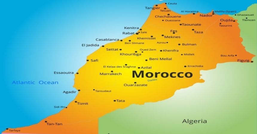
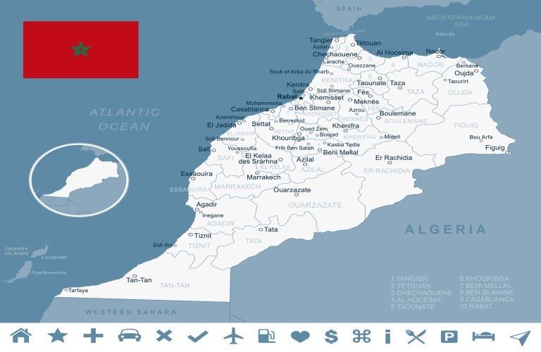
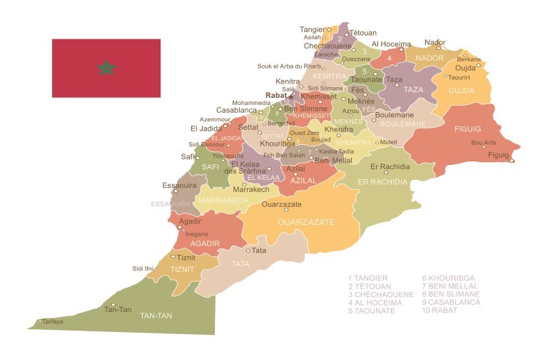
Casablanca and Rabat sit along the Atlantic side of the country. Fes lies inland to the northeast, while Chefchaouen pulls travelers farther north toward the Rif Mountains. Marrakech occupies a very different position farther south, backed by the High Atlas, and beyond those mountains the landscape gradually opens toward valleys, kasbah country and the Sahara gateways of southeastern Morocco. Essaouira, meanwhile, sends the journey back west until the Atlantic appears again.
On a small map, these places seem to form a manageable collection of famous names.
On the road, Morocco reveals the geography between them.
Mountain passes influence travel times, desert journeys unfold across several landscapes rather than beginning immediately outside Marrakech, and adding one northern city can change the logic of an otherwise southern route. This is why Morocco should not be planned by asking how many places fit into a list.
A more useful question is:
What shape does the journey create when those places are connected on the map?
That shape often tells you whether the trip will feel like a journey through Morocco or a repeated race across it.
Morocco Is Better Understood as a Meeting of Landscapes
There is no single geographical feature that explains Morocco in the way the Nile explains much of Egypt's classic tourism route.
Instead, several landscapes collide.
The Atlantic Ocean defines much of the western edge. The Mediterranean touches the north. The Rif Mountains shape northern Morocco, while the Atlas ranges form a dramatic geographical barrier farther south. Beyond them, southeastern valleys and increasingly arid landscapes lead toward Morocco's Saharan regions.
The country's famous cities occupy different parts of this system.
Casablanca is Atlantic-facing. Rabat belongs to the northern Atlantic corridor. Fes is inland. Marrakech sits south of the country's central urban belt. Chefchaouen belongs to the mountainous north. Merzouga lies deep in the southeast.
Once these relationships are understood, Morocco stops looking like a group of cities surrounding Marrakech.
It becomes a country of transitions.
The Most Useful Morocco Map Is Organized by Travel Function
For itinerary planning, it helps to think beyond administrative regions and instead ask what each part of Morocco contributes to the geographical structure of a journey.
| Map Function | Important Places | Geographic Effect | Planning Consequence |
|---|---|---|---|
| Atlantic gateways | Casablanca, Rabat | Western/northwestern entry | Useful for arrivals and northern progression |
| Northern cultural arc | Chefchaouen, Tangier, Tetouan | Pulls route toward Rif/Mediterranean | Needs deliberate northern allocation |
| Interior heritage zone | Fes, Meknes | Moves journey inland | Strong bridge between north and south |
| Southern urban anchor | Marrakech | Base south of central Morocco | Gateway toward Atlas and Atlantic extensions |
| Mountain transition | High Atlas | Separates Marrakech from southeast | Makes road journey part of itinerary |
| Pre-Sahara corridor | Ouarzazate, Dades, Todra | Extends east/southeast | Creates multi-stage desert approach |
| Saharan edge | Merzouga | Deep southeast | Requires meaningful travel commitment |
| Atlantic extension | Essaouira | West of Marrakech | Natural contrasting coastal branch |
This is more useful than simply calculating distance.
Morocco's geography influences not only how far you travel, but what kind of travel day lies between two destinations.
Casablanca Is Often the Doorway Rather Than the Destination That Organizes the Trip
Casablanca occupies an important place on Morocco's map because of its international air connections and Atlantic location.
That does not automatically make it the center of the sightseeing route.
This distinction is important when building a multi-city journey. Travelers arriving in Casablanca may naturally continue north toward Rabat or inland toward other imperial cities, while another itinerary may use Casablanca primarily as the arrival or departure gateway around a broader circuit.
The map therefore encourages a useful separation between transportation importance and sightseeing importance.
A city can be operationally crucial without needing to dominate the number of nights.
Casablanca illustrates that perfectly.
Its location can make the rest of Morocco easier to reach, but the journey should not repeatedly return there unless transportation genuinely requires it.
Rabat Belongs to the Atlantic Corridor Before Morocco Turns Inland
Rabat lies farther north along Morocco's Atlantic side and works particularly well within journeys moving between Casablanca and northern or inland regions.
Its position makes it geographically different from Marrakech despite both being major Moroccan cities.
This matters because the imperial cities are sometimes discussed as though they form one compact historical zone. In reality, Rabat, Meknes, Fes and Marrakech occupy different parts of the country, and traveling between them gradually reveals Morocco's scale.
Rabat's Atlantic position gives it a useful role near the beginning or end of a northern journey.
From there, the route can begin turning inland.
That change in direction is significant because Fes and Meknes introduce another geographical Morocco, removed from the coastal logic of Casablanca and Rabat.
Fes Is the Inland Pivot of Many Longer Morocco Routes
Fes is one of the most useful cities to locate correctly before planning Morocco.
It lies inland in northern-central Morocco, well north and east of Marrakech. That position allows it to connect naturally with Meknes and, with sufficient time, northern extensions such as Chefchaouen.
Fes also becomes extremely important when a journey eventually intends to reach the southeastern desert.
The route from Fes toward Merzouga approaches the Sahara through a different geographical direction from the classic Marrakech-to-desert journey. This creates the possibility of a highly satisfying circuit: entering the desert from one side and leaving toward another rather than retracing the same road.
For travelers considering Morocco imperial cities and Sahara tours, this is where the map becomes more valuable than a simple destination checklist.
Fes is not merely another medina.
It can be the hinge that turns a city journey into a cross-country route.
Chefchaouen Is Beautiful Precisely Because It Pulls You Away From the Main Axis
Chefchaouen sits in northern Morocco in the Rif Mountains.
Its location is part of its appeal, but also its itinerary cost.
Travelers sometimes see Casablanca, Fes, Chefchaouen, Marrakech and the Sahara on the same map and assume the blue city can be inserted anywhere. Geographically, Chefchaouen pulls the route north, which means it works best when the northern section is deliberately designed around it.
This does not make Chefchaouen inconvenient.
It makes it a choice.
If northern Morocco matters, allocating the necessary time allows Chefchaouen to become part of a coherent regional story rather than a long road excursion inserted between unrelated destinations.
The difference is important.
A map should not discourage travelers from going somewhere distant. It should reveal what that decision asks from the rest of the trip.
Marrakech Is a Southern Anchor, Not the Center of Morocco
Marrakech has such a powerful presence in international tourism that travelers can easily imagine the rest of Morocco radiating from it.
The map tells a more nuanced story.
Marrakech lies inland in the southwest, with the High Atlas rising nearby and the Atlantic coast accessible to the west. Its location makes it extremely useful for southern Morocco, but considerably less central to destinations such as Chefchaouen or Tangier.
From Marrakech, several distinct geographical directions become possible.
West leads toward Essaouira and the Atlantic.
South and southeast lead toward the Atlas Mountains and eventually the desert corridor.
North returns toward Morocco's central and northern cities.
This makes Marrakech an excellent route junction, but not necessarily a place to which every excursion should return.
The difference can save considerable travel time on a longer journey.
The Atlas Mountains Are Not Background Scenery on the Way to the Sahara
This is one of the most important lessons on the Morocco map.
Travelers frequently speak of taking a “desert trip from Marrakech,” which can unintentionally create the impression that Sahara dunes begin shortly beyond the city.
They do not.
The High Atlas stands between Marrakech and much of southeastern Morocco. Traveling toward the desert means crossing a major mountain landscape before reaching areas such as Ouarzazate and the valleys beyond.
This geography is not an inconvenience that needs to be endured before the “real” desert experience begins.
It is part of the journey.
Mountain roads, changes in elevation, villages, valleys and progressively drier landscapes explain how Morocco transforms from one environment into another.
The best desert routes respect this transition instead of pretending Marrakech and Merzouga are neighboring destinations.
Ouarzazate Is a Gateway, but the Desert Still Lies Beyond It
Ouarzazate occupies an important position southeast of the High Atlas.
Because it is associated so strongly with desert landscapes and film locations, travelers sometimes assume they have effectively reached the Sahara once they arrive.
Geographically, the journey continues.
Ouarzazate acts more like a transition point between the mountain crossing and the valleys leading deeper into southeastern Morocco. From this wider region, routes can continue through landscapes associated with the Dades Valley, Todra Gorge and ultimately the desert areas farther east.
This distinction is valuable because it changes how a road journey is perceived.
Marrakech to the Sahara is not simply one long transfer.
It can be understood as a sequence:
city → mountain crossing → kasbah country → valleys and gorges → increasingly arid southeast → dunes.
Once read that way, the geography becomes one of the reasons to travel overland.
Merzouga Is Deep in the Southeast, Not “Just Outside Marrakech”
Merzouga lies near the Erg Chebbi dune field in southeastern Morocco, close to the Algerian border.
This is one of the most important positions to understand on the entire map.
Reaching Merzouga from Marrakech involves substantial overland travel, which is why a well-paced Sahara experience should be understood as a multi-stage journey rather than a quick out-and-back excursion.
The same geography creates a valuable opportunity.
Instead of reaching Merzouga and returning along precisely the same route, longer journeys can continue toward Fes, creating a circuit across Morocco.
For Marrakech to Sahara desert journeys, the quality of the experience therefore depends as much on what happens between the city and the dunes as on the desert camp itself.
The Sahara is the destination.
Southeastern Morocco is the journey that makes reaching it meaningful.
Dades and Todra Explain Why Morocco's Desert Route Should Not Be Rushed
The Dades Valley and Todra Gorge sit within the southeastern route between the Atlas region and the Sahara.
Their position demonstrates why counting only headline destinations can create an unnecessarily hurried Morocco itinerary.
A traveler focused solely on Marrakech and Merzouga may see everything in between as transfer territory. Someone who understands the map recognizes that the landscape changes progressively and that valleys, gorges and fortified settlements provide much of the geographical narrative.
This is operational information that a simple map label cannot communicate.
The road has value because it explains how Morocco's terrain changes.
There are journeys where flying saves time.
There are others where removing the road would remove part of the reason for going.
The southeastern Morocco route often belongs to the second category.
Essaouira Creates a Westward Escape Rather Than Another Stop on the Desert Route
Essaouira lies on Morocco's Atlantic coast west of Marrakech.
Its location gives it a very different itinerary function from Ouarzazate or Merzouga.
Travelers who have spent time in Marrakech can head toward Essaouira for a coastal contrast without committing to the much larger geographical journey required for the Sahara. Conversely, travelers returning from a long desert circuit can use the Atlantic coast as a deliberately slower final chapter.
What does not work geographically is pretending Essaouira lies somewhere along the Marrakech–Sahara road.
It is a separate direction.
That distinction helps travelers choose between extensions based on the kind of trip they want.
The desert takes the journey across the mountains and southeast.
Essaouira takes it west until Morocco meets the Atlantic.
Morocco's Best Multi-City Routes Often Form a Loop
This is where Morocco differs significantly from Jordan's almost linear classic route or Egypt's Nile spine.
Morocco often rewards circular thinking.
Imagine a journey beginning around Casablanca, progressing through Rabat and northern or inland cities, reaching Fes, crossing toward southeastern Morocco, entering the Sahara, continuing through the valleys and Atlas region and eventually arriving in Marrakech.
The route does not need to retrace every previous transfer.
Alternatively, a southern journey can be organized around Marrakech, the Atlas, desert regions and an Atlantic extension without trying to reach the far north.
This loop principle is one of the most useful things a Morocco map can teach.
If every destination requires returning to Marrakech or Casablanca before continuing, there is a reasonable chance the geography has not yet been fully solved.
A Straight-Line Distance Can Be Misleading in Morocco
Two places can appear relatively close while mountains make the road journey slower than expected.
This is particularly relevant around the Atlas and southeastern Morocco.
For that reason, travelers should be cautious about building a route solely from kilometer figures. Road type, terrain, elevation and sightseeing stops all affect how a transfer feels.
The same five-hour journey can have two entirely different meanings.
One may be five hours of transportation that simply needs to be completed.
Another may include mountain passes, viewpoints, villages and dramatic changes of landscape that become part of the day's experience.
Morocco contains plenty of the latter.
That is why good geographical planning considers travel quality, not just travel quantity.
Northern and Southern Morocco Compete for Time More Than the Map Suggests
Chefchaouen and the Rif belong to one geographical story.
Marrakech, the High Atlas and the southeastern desert belong to another.
Fes can help connect these worlds, but combining the full north and south still requires enough time.
This becomes particularly important on shorter holidays.
Adding Chefchaouen may mean reducing time elsewhere. Adding Merzouga requires protecting several days for the desert progression. Adding Essaouira turns the journey toward the Atlantic.
None of these decisions is wrong.
The map simply makes the trade-offs visible.
One of the easiest ways to damage a Morocco itinerary is to keep every destination while reducing the time allocated to the roads between them.
The result may look impressive on paper while feeling exhausting on the ground.
How We Use Morocco's Geography When Designing a Private Journey
When Magnificent Travel builds a Morocco itinerary, we first identify the route's geographical anchors rather than filling each day with attractions.
If Marrakech and the Sahara are essential, the Atlas crossing and southeastern corridor need enough time to work properly. If Fes is also essential, we consider whether the desert can connect the two cities instead of creating unnecessary returns. If Chefchaouen matters, the northern section needs its own space. If relaxation is the priority after cultural touring, Essaouira may provide a more geographically appropriate conclusion than another inland city.
This approach becomes especially important with customized Morocco private tours, where adding flexibility should never mean adding geographical disorder.
A private vehicle can make ambitious routes possible.
It cannot make Morocco smaller.
Professional route design respects that difference.
The Map Should Help You Decide What to Leave Out
Travel planning often treats maps as tools for adding destinations.
Morocco's map is equally useful for removing them.
If you have a week and your priorities are Marrakech, the Atlas and the Sahara, the far north may deserve another journey. If Fes, Chefchaouen and Morocco's imperial heritage are the main interests, crossing the entire country simply to add a photograph in the dunes may weaken rather than improve the trip.
With more time, these worlds can connect beautifully.
That is the advantage of understanding Morocco as a circuit rather than a checklist.
The strongest itinerary does not necessarily visit the largest number of famous places.
It creates a geographical story in which the landscapes between destinations make sense, the direction changes deliberately, and the traveler understands why each place follows the one before it.
Once Morocco is read that way, the map becomes far more than orientation.
It becomes the first draft of the journey.
Frequently Asked Questions About the Map of Morocco
1. Is Marrakech close to the Sahara Desert?
Not in the sense many first-time visitors expect. Reaching the major southeastern desert areas from Marrakech requires crossing the High Atlas and continuing through substantial stretches of southern Morocco, which is why a properly paced Sahara journey normally involves more than a simple day excursion.
2. Which Moroccan city is the most useful starting point for a first trip?
There is no universal geographical starting point because international flights and planned regions matter. Casablanca is an important gateway, while Marrakech can be particularly efficient for southern routes and Fes can work well when northern Morocco and the Sahara are being connected.
3. Can Fes and Marrakech be combined without returning through Casablanca?
Yes. They can form different anchors within a broader overland journey, and longer routes may connect them through southeastern Morocco and the Sahara. This can create a circuit rather than requiring travelers to repeatedly return to the Atlantic gateway.
4. Why does driving in Morocco sometimes take longer than the map suggests?
Terrain is a major factor, particularly around the Atlas Mountains and southeastern valleys. Road conditions, mountain sections and worthwhile stops can all affect travel time, so straight-line distance or kilometer counts alone are poor measures of how a Morocco transfer will feel.
5. Does Chefchaouen fit naturally into a Marrakech and Sahara trip?
Chefchaouen lies far to the north in the Rif Mountains, while Marrakech and the principal desert routes occupy southern and southeastern Morocco. Combining them is possible, but doing so meaningfully requires enough time for the itinerary to span both geographical zones.
6. What places do travelers normally pass before reaching Merzouga?
The exact route varies, but journeys approaching from Marrakech commonly move through the High Atlas and southeastern landscapes associated with Ouarzazate, valleys, gorges and kasbah country before reaching the Merzouga area. This progression is an important part of the experience.
7. Is Essaouira on the way from Marrakech to the Sahara?
No. Essaouira lies west of Marrakech on the Atlantic coast, whereas the principal Sahara routes move east and southeast across the Atlas Mountains. Choosing Essaouira therefore creates a coastal extension rather than a stop along the desert journey.
8. Which side of Morocco has the Atlantic Ocean?
Morocco's long Atlantic coastline runs along the western side of the country, including major cities and destinations such as Casablanca, Rabat and Essaouira. The country's northern coastline also meets the Mediterranean, giving northern Morocco a distinctly different geographical orientation.
9. Why are the Atlas Mountains important when planning a Morocco itinerary?
The Atlas ranges influence routes between Marrakech and southeastern Morocco, meaning the mountains are both a geographical barrier and an important part of the travel experience. Crossing them affects driving time while introducing landscapes that distinguish southern routes from Morocco's northern cities.
10. Is it better geographically to visit the Sahara from Marrakech or Fes?
Both can work because they approach southeastern Morocco from different directions. On longer journeys, this becomes an advantage: travelers can enter the desert corridor from one city and continue toward the other, reducing the need to retrace the same route.
11. Can northern Morocco and the Sahara comfortably fit into a short trip?
Usually, trying to cover both geographical extremes within a short visit creates substantial road time and frequent hotel changes. A more satisfying short journey normally concentrates on one coherent region, while longer trips can connect north, imperial cities and the southeast more naturally.
12. What makes a Morocco map especially useful for itinerary planning?
Morocco combines Atlantic coastline, inland imperial cities, mountain ranges and distant Saharan regions, so visual distance can be misleading. Reading the map as a network of loops and landscape transitions helps travelers recognize sensible combinations before committing to hotels and daily sightseeing.

A travel professional specializing in tailor-made travel planning, guest experience management, and multi-destination tourism operations.
With over 23 years of experience in the travel industry, he designs and manages private and cultural tours for international travelers across Türkiye, Greece, Egypt, Jordan, Morocco, and other destinations.
He has strong expertise in both online and face-to-face guest communication, sales processes, and end-to-end travel operations.
Working closely with hotels, travel agencies, and local partners, he ensures smooth coordination and high-quality travel experiences at every stage of the journey.
His focus is on delivering personalized, reliable, and seamless travel experiences for international guests worldwide.