Map of Jordan: Understand the Cities, Desert and Travel Routes
Updated: August 2026
Jordan is one of those countries that looks almost effortless to plan until you begin placing actual travel days between the points on the map.
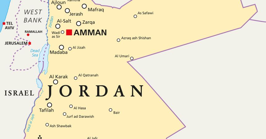
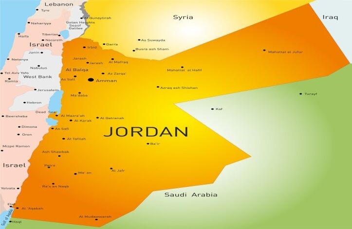
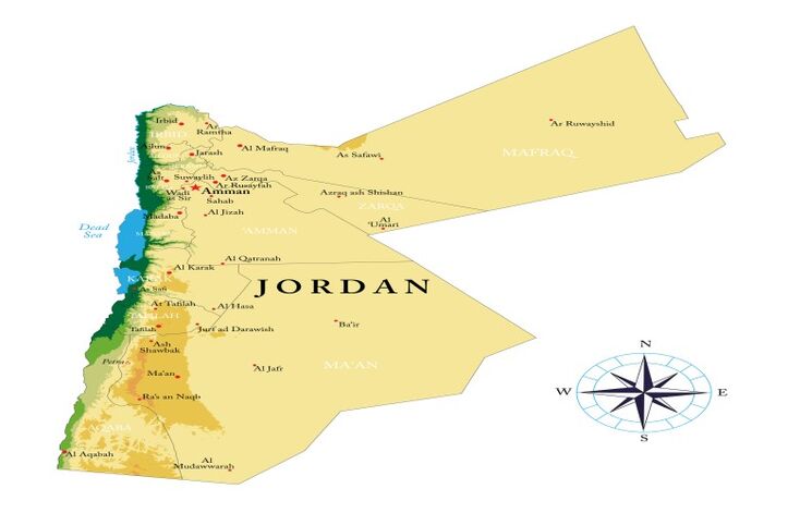
Amman sits in the north, close enough to Jerash for the two to feel naturally connected. The Dead Sea lies southwest of the capital, with Madaba and Mount Nebo forming another important western cluster. Continue south and Petra becomes the central landmark of the journey, while Wadi Rum stretches farther toward the Saudi Arabian border and Aqaba finally reaches the Red Sea.
That basic geography gives Jordan an advantage many larger countries do not have: its classic first-time route can be read almost vertically from north to south.
The map, however, still matters.
Petra is not “near” Amman simply because Jordan looks narrow. The Dead Sea is not automatically on the way to every destination. Wadi Rum and Aqaba belong naturally together, while Jerash makes much more sense at the beginning or end of the northern section. A route that repeatedly returns to Amman can therefore consume more time than a journey that follows the country’s geography in one direction.
Jordan is compact enough to combine several major experiences in one trip, but it becomes much easier once you stop treating the country as a circle around the capital.
Jordan’s Shape Encourages a Directional Journey
Jordan stretches much farther north to south than east to west across the areas most visitors travel.
This matters because the country’s most familiar destinations line up in a remarkably practical sequence.
Amman and Jerash sit toward the north. Madaba, Mount Nebo and the Dead Sea form a western zone. Petra lies considerably farther south. Wadi Rum continues the journey into desert country, while Aqaba gives the route a natural endpoint beside the Red Sea.
This is different from countries where famous destinations radiate in several competing directions.
Jordan’s classic tourism geography often rewards progression.
The question becomes less “What should we visit from Amman?” and more:
How should we move through Jordan so that each region leads naturally into the next?
That shift removes a surprising amount of unnecessary driving.
Read Jordan as Five Travel Zones, Not One Small Country
A conventional political map does not tell travelers enough about how Jordan actually works on the ground.
A more useful planning map divides the country into functional travel zones.
| Travel Zone | Key Destinations | Geographic Character | Route Planning Meaning |
|---|---|---|---|
| Northern Jordan | Amman, Jerash, Ajloun | Urban and greener north | Best grouped early or late |
| Western Highlands | Madaba, Mount Nebo | Elevated cultural corridor | Natural bridge toward Dead Sea |
| Dead Sea Rift | Dead Sea, Bethany area | Deep western depression | Works as a distinct westward detour |
| Southern Heritage Corridor | Petra, Little Petra | Mountainous south | Major cultural anchor |
| Desert & Red Sea | Wadi Rum, Aqaba | Desert to coast | Strong natural finishing sequence |
This framework is more useful than memorizing governorates because it immediately reveals which places belong in the same travel chapter.
Jordan’s famous sites may be close enough to combine within one journey, but they do not all solve the same travel purpose.
Amman Is the Gateway, Not the Center of the Entire Route
Most travelers enter Jordan through Amman, so the capital can feel like the hub around which the country revolves.
Geographically, that is only partly true.
Amman is extremely useful at the beginning or end of a journey, especially for northern sightseeing and international arrivals, but repeatedly returning there between Petra, the Dead Sea and Wadi Rum rarely improves the route.
This is where airport thinking can distort geography.
Because the international gateway is near Amman, travelers sometimes assume every section of Jordan should begin and finish there. In reality, the strongest itineraries often leave the capital once and continue southward through the country before either returning at the very end or departing through another logical gateway.
For travelers joining Jordan cultural and Petra tours, this north-to-south structure can make the journey feel much calmer because transfers support the route rather than interrupting it.
Amman introduces Jordan.
It does not need to reset Jordan every two days.
Jerash Belongs With Amman, Not Petra
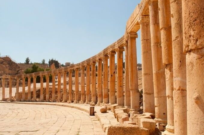
Jerash sits north of Amman and is one of the country’s most important archaeological destinations.
Its location gives it a very clear route identity.
It works naturally as part of the northern Jordan section, often combined with Amman or other nearby northern sites. Trying to insert Jerash after Petra or Wadi Rum usually creates unnecessary backtracking because the traveler has already moved far south.
This is exactly why the map should be consulted before attractions are placed into a day-by-day schedule.
Jerash may be one of the first names travelers write down.
The map tells you when it belongs.
That distinction is small on paper and substantial on the road.
Madaba and Mount Nebo Create a Western Bridge
Madaba and Mount Nebo occupy a particularly useful position southwest of Amman.
They can form a cultural and geographical bridge toward the Dead Sea or the road continuing south, depending on the wider route.
Madaba’s mosaic tradition and Mount Nebo’s biblical associations belong to a different historical context from Amman’s urban experience or Petra’s Nabataean world, yet geographically they fit well within a western Jordan journey.
This is where Jordan’s compactness becomes genuinely helpful.
Several important experiences can be connected without needing a domestic flight or an entire day simply to reach the next region.
Even so, travelers should not confuse “relatively close” with “walkable” or “next door.”
Jordan remains a road-based destination once you move beyond its towns.
The map helps group the stops.
Transportation still turns those groups into a practical day.
The Dead Sea Is West of the Main North–South Axis
The Dead Sea lies along Jordan’s western side, forming part of the great rift system that extends through the region.
Its position matters because it is not simply “between Amman and Petra” in the same way one town may lie directly along a highway corridor.
Depending on the route, reaching the Dead Sea can require a deliberate turn west before continuing south.
That can be entirely worthwhile.
The Dead Sea offers one of Jordan’s most distinctive changes of landscape, moving travelers from highland cities and archaeological sites toward a dramatic low-lying environment very different from the rest of the country.
Its best geographical use often comes as either a dedicated relaxation stop or part of a western route involving Madaba and Mount Nebo.
The mistake is not including the Dead Sea.
The mistake is assuming it fits anywhere without influencing the driving pattern.
Petra Is the Geographic and Emotional Center of Most First Trips
Petra lies in southern Jordan, far enough from Amman that the journey should be treated as a meaningful regional transition rather than a short excursion.
Once travelers reach Petra, the country begins to feel very different.
The landscape becomes more mountainous and desert-like, while the route has clearly moved beyond northern Jordan. This is one reason Petra works so powerfully as the central anchor of a first-time journey.
On the map, Petra also creates a major decision point.
Continue south and Wadi Rum follows naturally. Continue farther and Aqaba becomes the coastal endpoint. Return north immediately and the traveler gives up the advantage of Jordan’s directional geography.
Petra therefore does more than justify a long visit.
It changes what should happen next.
The King’s Highway and Desert Highway Solve Different Problems
Jordan’s north–south road geography is not a single road story.
Travelers commonly hear about the King’s Highway and Desert Highway, and the distinction is useful even at map level.
The King’s Highway follows a more historic, scenic route through parts of western Jordan, passing landscapes and cultural stops that can contribute to the journey itself. The Desert Highway offers a more direct north–south transportation function across a different landscape.
This is not a detailed road guide, so the important point is conceptual:
one route can make the transfer part of the sightseeing; another can prioritize efficiency.
That choice matters particularly between the Amman/Dead Sea region and Petra.
A traveler who wants Madaba, Mount Nebo or other meaningful stops may value a slower geographical progression. Someone whose only objective is reaching Petra efficiently may prioritize another road logic.
The map does not decide which road you should drive.
It shows why both exist within different travel philosophies.
Petra and Wadi Rum Are One of Jordan’s Strongest Geographic Pairings
Few destination combinations in Jordan feel as natural as Petra and Wadi Rum.
They are not similar experiences.
That is precisely why the pairing works.
Petra is archaeological and architectural, shaped by Nabataean history and the mountain environment around Wadi Musa. Wadi Rum moves farther into desert country, where the landscape itself becomes the main experience.
Geographically, Wadi Rum lies south of Petra, so continuing there follows the direction of the journey instead of reversing it.
This is the kind of route relationship travelers should look for throughout Jordan: two major destinations that differ dramatically while still belonging naturally in sequence.
For Petra and Wadi Rum private tours, that relationship is operationally valuable because the transition itself is straightforward enough to preserve the sense of progression rather than turning the day into a logistical reset.
Wadi Rum Is Not Just a Desert Outside Petra
A small map can make Wadi Rum appear like an extension of Petra’s surroundings.
It deserves more respect than that.
The protected desert area lies deeper in southern Jordan and creates an environment defined by sandstone mountains, wide desert spaces and Bedouin cultural traditions. The travel experience is therefore very different from Petra, even though the two can be combined efficiently.
This distinction also affects accommodation and timing.
Travelers heading into Wadi Rum are not simply driving to another archaeological attraction before lunch. They are entering a different geographical setting where jeep exploration, desert camps and sunset or sunrise experiences can influence the rhythm of the stay.
The map should therefore communicate two things at once:
Wadi Rum fits naturally after Petra.
Wadi Rum should still be allowed to feel like a new destination.
Jordan Rewards Overland Travel More Than Repeated Domestic Flying
Unlike larger countries where major tourism regions can be separated by vast distances, Jordan’s classic travel corridor works naturally by road.
That has an important effect on how the country feels.
The journey between destinations can reveal changes in elevation, desert landscapes, agricultural areas and settlement patterns that would disappear if every major movement happened through airports.
This does not mean every road transfer is inherently interesting.
It means Jordan’s geography gives overland movement a logical role because the primary destinations form a relatively continuous north–south progression.
That continuity is one of the country’s greatest itinerary advantages.
You can arrive in one landscape and leave in another without needing to reset the trip completely.
How We Read the Jordan Map Before Building the Route
When Magnificent Travel builds a Jordan journey, the map usually answers several questions before the day-by-day program is written.
Where does the international traveler arrive? Does Jerash belong immediately with Amman? Should Madaba and Mount Nebo connect toward the Dead Sea or become part of the road south? Is Petra followed by Wadi Rum? Does Aqaba deserve to become the finish, or should the route turn back toward Amman for the international departure?
These decisions become especially important on customized Jordan cultural tours, because customization should improve geographical flow rather than simply add more attractions.
The strongest route is not always the one with the largest number of stops.
It is the one where every transfer has a clear reason.
Jordan’s map makes that easier than many travelers expect.
Read Jordan From North to South Before Adding Detours
For a first journey, one of the simplest ways to understand the country is to read the map vertically.
Begin with Amman and Jerash in the north.
Move west or southwest toward Madaba, Mount Nebo and the Dead Sea when those experiences matter.
Continue south to Petra.
Then let Wadi Rum carry the journey deeper into southern Jordan before deciding whether Aqaba should provide the final coastal chapter.
Only after that core route makes sense should additional detours be considered.
This approach does not prescribe one fixed itinerary, and the route can easily be reversed. What it does is reveal Jordan’s natural travel logic before sightseeing preferences begin complicating it.
The country may be compact, but its geography still deserves respect.
Once the map is used as a planning tool rather than a background illustration, Jordan becomes one of the clearest countries in the region to organize into a coherent, memorable journey.
Frequently Asked Questions About the Map of Jordan
1. Where is Jordan located on the world map?
Jordan lies in the Middle East, bordered by Syria to the north, Iraq to the northeast, Saudi Arabia to the east and south, and Israel and the Palestinian territories to the west, with a short Red Sea coastline at Aqaba.
2. Where is Amman on the map of Jordan?
Amman is located in northern-central Jordan and serves as the country’s principal urban and international gateway. Its position makes it particularly convenient for beginning with northern attractions such as Jerash before traveling south toward Petra and Wadi Rum.
3. Is Jerash north or south of Amman?
Jerash lies north of Amman, which makes it geographically sensible to visit during the northern section of a Jordan journey. Including it after Petra or Wadi Rum would generally require unnecessary backtracking through a part of the country already passed.
4. Where is the Dead Sea compared with Amman?
The Dead Sea lies southwest of Amman along Jordan’s western edge. It can be combined naturally with Madaba and Mount Nebo, although reaching it means moving west from the main north–south travel axis rather than simply continuing directly toward Petra.
5. Is Petra close to Amman?
Petra lies considerably south of Amman, so the journey should be treated as a meaningful regional transfer rather than a short excursion. Road choice and intermediate sightseeing can influence whether the travel day functions mainly as transportation or as part of the experience.
6. Is Wadi Rum close to Petra?
Wadi Rum lies south of Petra and forms one of Jordan’s strongest geographical combinations. Their proximity makes it natural to continue from Petra into the desert rather than returning north, while the two destinations provide completely different archaeological and landscape experiences.
7. Where is Aqaba compared with Wadi Rum?
Aqaba lies southwest of Wadi Rum on the Gulf of Aqaba at Jordan’s Red Sea coast. This position makes it a logical final destination after the desert when travelers want to add swimming, diving or several slower coastal days.
8. Are the Dead Sea and Aqaba close to each other?
No. They lie in different parts of Jordan’s western geography, with the Dead Sea much farther north and Aqaba at the far southern tip. Their roles in an itinerary are therefore different even though both are associated with water and relaxation.
9. What is the most logical direction to travel through Jordan?
A north-to-south journey often works especially well, beginning around Amman and Jerash before continuing toward the Dead Sea or Madaba, Petra, Wadi Rum and potentially Aqaba. The same geographical logic can also operate effectively in reverse.
10. What is the King’s Highway in Jordan?
The King’s Highway is a historic north–south road corridor through western Jordan that can connect cultural and scenic locations on the way toward Petra. Its value lies in allowing parts of the road journey itself to contribute to the travel experience.
11. Do I need domestic flights to travel around Jordan?
For most classic Jordan routes, domestic flying is unnecessary because the principal destinations can be connected effectively by road. The country’s north–south geography makes private vehicles, coaches and other overland transportation particularly suitable for multi-destination journeys.
12. Why should I look at a Jordan map before planning the itinerary?
A map reveals how naturally many of Jordan’s major destinations align from north to south while showing where western or eastern detours alter the route. Understanding these relationships helps reduce backtracking and gives each transfer a clearer geographical purpose.

A travel professional specializing in tailor-made travel planning, guest experience management, and multi-destination tourism operations.
With over 23 years of experience in the travel industry, he designs and manages private and cultural tours for international travelers across Türkiye, Greece, Egypt, Jordan, Morocco, and other destinations.
He has strong expertise in both online and face-to-face guest communication, sales processes, and end-to-end travel operations.
Working closely with hotels, travel agencies, and local partners, he ensures smooth coordination and high-quality travel experiences at every stage of the journey.
His focus is on delivering personalized, reliable, and seamless travel experiences for international guests worldwide.