Map of Egypt: Understand the Nile, Cities and Travel Routes
Updated: August 2026
Egypt becomes much easier to plan when you stop looking at the map as a collection of famous archaeological sites and start noticing the line that connects much of the country travelers actually visit.
That line is the Nile.
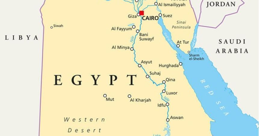
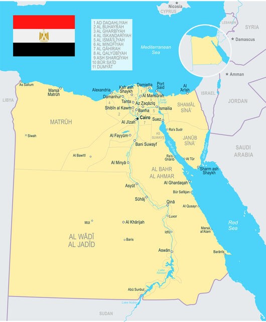
Cairo and Giza sit in northern Egypt, while Luxor and Aswan lie hundreds of kilometers farther south along the river. Between Luxor and Aswan is the stretch of the Nile most closely associated with multi-day cruises, where temples and ancient sites create a remarkably natural geographical sequence. Continue beyond Aswan and Abu Simbel takes you significantly farther south toward the Sudanese border.
Move east instead, however, and the geography changes. Hurghada lies on the Red Sea coast rather than along the Nile. Sharm El Sheikh is farther away again, positioned on the southern Sinai Peninsula. Alexandria sits on the Mediterranean in the north, while the Western Desert extends into an entirely different landscape west of the Nile Valley.
A small map can make all of these places look comfortably close.
A real journey reveals a different Egypt.
Understanding the country's travel geography helps explain why some combinations flow almost effortlessly, why others require a flight or substantial road journey, and why a destination that appears to be a simple addition can change the structure of the entire trip.
Egypt Has a Travel Spine, and the Nile Defines It
Few major tourism countries have geography as visually understandable as Egypt once the Nile is placed at the center of the map.
The river enters Egypt from the south and travels north toward the Mediterranean. Along or close to this corridor lie many of the places associated with ancient Egyptian history, including Aswan, Kom Ombo, Edfu, Luxor and, much farther north, the Cairo area.
This creates an unusually strong travel logic.
Instead of jumping randomly between historical cities, travelers can follow a geographical progression through the Nile Valley. The route does not need to be completed entirely by road or river; domestic flights are often part of the journey. What matters is that the destinations themselves form a recognizable north-south relationship.
That changes when you add the Red Sea, Sinai or Western Desert.
Those places are not simply additional points on the same line.
They pull the journey away from it.
Upper Egypt Is South, Even Though the Name Sounds Like North
One of the most common geographical confusions begins with the terms Upper Egypt and Lower Egypt.
Upper Egypt is in the south.
Lower Egypt is in the north.
The terminology follows the Nile's elevation and flow rather than the orientation of a modern map. The river flows from the higher lands of the south toward the Mediterranean in the north, so Aswan and Luxor belong to Upper Egypt, while the Nile Delta and northern areas belong to Lower Egypt.
For travelers, remembering this makes historical and geographical descriptions considerably easier to follow.
| Travel Geography | Main Reference Points | Position | Route Planning Meaning |
|---|---|---|---|
| Cairo & Giza | Cairo, Giza, Saqqara | North | Principal international gateway |
| Nile Valley | Luxor, Edfu, Kom Ombo, Aswan | South / Upper Egypt | Egypt's strongest historical travel corridor |
| Far South | Abu Simbel | South of Aswan | Requires deliberate extension |
| Red Sea Coast | Hurghada, Marsa Alam | East of Nile Valley | Natural relaxation extension from Upper Egypt |
| Sinai | Sharm El Sheikh | Across the Gulf of Suez | Separate resort geography |
| Mediterranean North | Alexandria | Northwest of Cairo | Northern cultural extension |
| Western Desert | Bahariya, Siwa and desert regions | West of Nile | Separate overland planning environment |
The map becomes much more useful once these are seen as different geographical systems rather than one enormous sightseeing zone.
Cairo Is the Gateway, but It Sits Far North of Ancient Upper Egypt
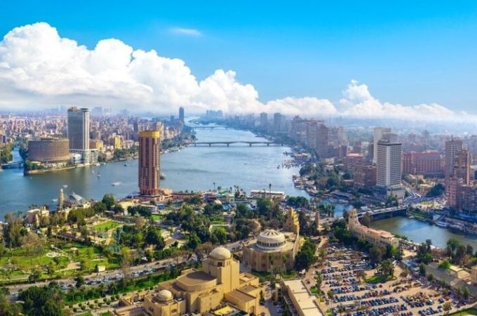
Cairo dominates most first visits to Egypt because the country's principal international gateway, the Giza pyramid complex, major museums and enormous urban center are concentrated in the same broad metropolitan area.
Geographically, however, Cairo sits well north of Luxor and Aswan.
That is important.
A traveler does not finish sightseeing at the pyramids and casually drive down the road to Luxor for dinner. Moving into Upper Egypt represents a significant transition, which is why domestic flights and overnight rail options appear frequently in Egypt travel planning.
This separation actually works in the country's favor.
Cairo feels fundamentally different from the Nile cities farther south. The capital introduces modern Egypt alongside the monuments around Giza and Saqqara, while arriving in Luxor changes the landscape and historical context.
On well-designed Cairo and Nile cruise tours, that geographical transition becomes part of the journey rather than an inconvenient gap between attractions.
The map makes the scale visible.
Good transportation makes it manageable.
Giza Is Beside Cairo, but It Is Not Simply Another Cairo Neighborhood
From an international travel perspective, Cairo and Giza are often spoken about almost interchangeably.
On the map, however, the distinction is useful.
Giza lies on the western side of the Nile within the greater Cairo urban area, and the famous Giza Plateau sits beyond the river from much of central Cairo. Saqqara lies farther south, extending the archaeological geography beyond the pyramids most visitors immediately recognize.
This matters operationally because “Cairo sightseeing” can involve substantial movement across a very large metropolitan area.
A hotel in one part of the city, the Egyptian Museum or Grand Egyptian Museum, the Giza Plateau, Saqqara and Islamic Cairo are not all concentrated within a compact pedestrian center.
The map therefore provides a valuable planning lesson before the journey even leaves Cairo:
proximity within one metropolitan region does not necessarily mean short travel times.
Urban geography and national geography create different challenges.
Egypt contains both.
Luxor Is Where the Ancient Nile Landscape Becomes Concentrated
Travel south from Cairo and Luxor eventually becomes one of the most important reference points on the Egypt map.
Ancient Thebes developed around this section of the Nile, and modern sightseeing is still shaped by the river's geography. Luxor Temple and Karnak occupy the east-bank side of the historical landscape, while the Valley of the Kings and other major necropolis sites lie on the west.
This east-west distinction matters because ancient Egyptian geography attached symbolic significance to the movement of the sun and the relationship between the living landscape and the west-bank necropolises.
For modern travelers, the practical lesson is simpler: Luxor is not a single archaeological compound.
Sites spread across both sides of the river.
At the national level, Luxor also performs another role. It sits at the northern end of the Nile section most commonly associated with cruises toward Aswan.
That makes Luxor both a destination and a gateway into a geographical sequence.
Between Luxor and Aswan, the Map Starts Working for You
The Luxor–Aswan corridor is one of those rare parts of travel geography where moving between destinations can become part of the destination itself.
Edfu and Kom Ombo sit along the river between the two cities, allowing archaeological sightseeing and transportation to follow the same general direction.
This explains why Nile cruises fit Egypt so naturally.
A cruise is not merely a floating hotel added for atmosphere. It follows a geographical corridor where several major historical sites lie along or near the river.
That does not mean every traveler must cruise.
The important map-based insight is that Luxor, Edfu, Kom Ombo and Aswan belong to the same strong travel axis.
Compare that with trying to combine Luxor, Sharm El Sheikh and Alexandria in the same manner.
All three are worthwhile destinations.
Only one combination follows the Nile's geographical logic.
Aswan Is Not the End of Egypt
On many classic Egypt itineraries, Aswan feels like the southern endpoint.
Geographically, it is not.
Aswan lies deep in southern Egypt near the First Cataract region of the Nile and provides access to Philae, Nubian landscapes and other experiences associated with the country's south. Yet Abu Simbel lies considerably farther beyond it.
This distinction matters because travelers occasionally treat Abu Simbel as though it were a site immediately outside Aswan.
It is an extension.
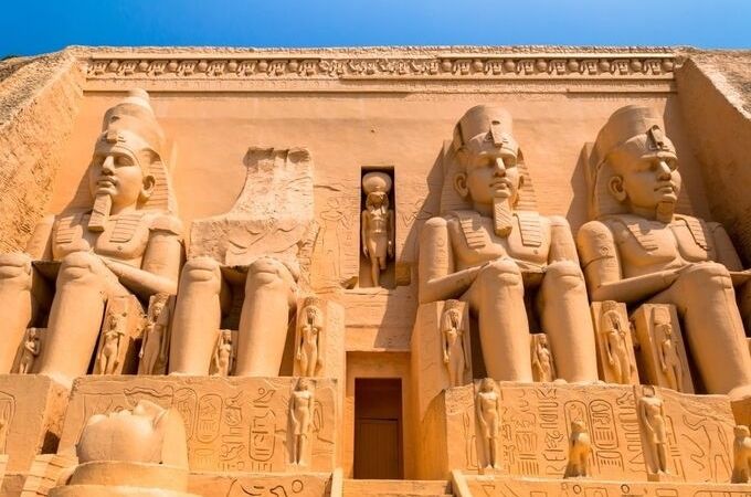
The temples lie close to Lake Nasser in far southern Egypt, much nearer the Sudanese border than Cairo. Reaching them therefore requires deliberate transportation planning, commonly by road or air depending on the itinerary and arrangements.
For travelers considering Egypt tours with Abu Simbel and Aswan, the key geographical decision is whether the far-southern extension deserves the additional travel required.
For many people, it absolutely does.
The map simply ensures that the decision is informed.

A Nile Cruise Does Not Travel from Cairo to Aswan
This misconception is surprisingly persistent.
Look at the Nile running through the length of Egypt and it seems reasonable to imagine boarding a cruise near Cairo and slowly sailing south toward Luxor and Aswan.
That is not how the standard sightseeing cruise geography works.
The classic multi-day Nile cruise sector is principally associated with the Luxor–Aswan corridor, rather than Cairo-to-Aswan transportation.
Understanding this before booking prevents several planning errors. Cairo normally forms one section of the journey, while Upper Egypt and the cruise form another, connected through appropriate domestic transportation.
The river may be continuous on the map.
The tourism operation is not one continuous cruise network.
This is precisely where geographical knowledge becomes operational information rather than trivia.
Hurghada Pulls the Journey East From the Nile
Hurghada lies on the Red Sea coast, east of the Nile Valley.
Its position creates one of Egypt's most useful geographical contrasts.
After several days focused on temples, tombs and ancient history around Luxor and the Nile, travelers can move toward the Red Sea for beaches, resorts, diving or simple downtime.
Luxor is particularly relevant because the two regions can be connected overland, making the historical Nile-to-Red-Sea combination geographically understandable.
The important point is that Hurghada does not sit “after Aswan” in the same way Edfu sits between Luxor and Aswan.
It requires leaving the Nile corridor.
This difference should shape expectations.
Adding Hurghada is not adding another historical stop.
It changes both the direction and the purpose of the journey.
Sharm El Sheikh Changes the Map More Than Hurghada Does
Hurghada and Sharm El Sheikh are often grouped together because both are major Red Sea resort destinations.
Geographically, they are very different additions.
Hurghada sits on mainland Egypt's Red Sea coast. Sharm El Sheikh lies on the southern Sinai Peninsula, across the Gulf of Suez from mainland Egypt.
That means a traveler should not choose between them solely by comparing hotel photographs or beaches.
The route matters.
If the journey is already moving through Luxor and Upper Egypt, Hurghada can offer one geographical logic. If Sharm El Sheikh is the priority, flight connections may make a different itinerary structure more sensible.
Sinai also opens the possibility of destinations such as St Catherine's, creating an entirely separate regional travel pattern.
A map of Egypt makes this immediately clear:
the Red Sea is not one compact resort strip.
Alexandria Extends the Journey North Rather Than South
While most first-time Egypt routes pull south from Cairo toward Luxor and Aswan, Alexandria goes in the opposite direction.
The Mediterranean city lies northwest of Cairo on Egypt's northern coast.
That makes it geographically distinct from the Nile cruise corridor, but relatively logical as a northern extension from Cairo.
For travelers particularly interested in Mediterranean history, Alexandria can add another layer to the journey without requiring movement into an entirely remote region.
However, it should not be inserted casually between Luxor and Aswan simply because it appears on a list of Egypt's major cities.
Sequence matters.
If Alexandria is included, its natural relationship is primarily with the northern part of the journey.
The map does not tell you whether Alexandria deserves two nights.
It tells you where those nights belong.
The Western Desert Creates a Completely Different Egypt
Move west of the Nile and the country's travel geography changes dramatically.
The Western Desert occupies an enormous portion of Egypt, with oases and desert landscapes scattered far beyond the historical river corridor. Siwa, for example, lies deep in western Egypt near the Libyan border and should never be imagined as a minor detour from Cairo.
This is another example of scale disappearing on a screen.
A traveler attracted to desert landscapes may find these regions extraordinary, but incorporating them requires an itinerary designed around overland distances and different logistical conditions.
The Western Desert is therefore better understood as a distinct geographical extension rather than an accessory to a standard Cairo–Luxor–Aswan journey.
Egypt's famous monuments follow the Nile.
The country itself extends far beyond it.
The Strongest First-Time Route Usually Has a Direction
Egypt itineraries work particularly well when their geography has a visible flow.
Cairo can introduce the north.
A domestic connection can move the journey into Upper Egypt.
Luxor and Aswan can then form the historical Nile section, with a cruise linking major sites between them. Abu Simbel can extend the route farther south, while a Red Sea stay can deliberately turn the journey east for relaxation.
The direction can also be reversed.
There is nothing inherently superior about traveling north to south rather than south to north. Flight availability, cruise schedules and international arrival or departure arrangements can make either sequence appropriate.
What matters is avoiding unnecessary geographical repetition.
A good Egypt itinerary should feel like movement through the country rather than a series of returns to Cairo simply because every component was planned separately.
Domestic Flights Solve Geography, but They Should Not Hide It
Egypt's domestic air network is valuable precisely because the country is larger than its tourism maps suggest.
Cairo to Aswan or Luxor is a substantial geographical movement. Flying can preserve sightseeing time that would otherwise be consumed by a long overland sector. Abu Simbel can also involve air access depending on the chosen arrangement, while Red Sea and Sinai combinations may benefit from flights when geography becomes more complicated.
This does not mean every transfer should be airborne.
The Luxor–Aswan Nile corridor demonstrates the opposite: sometimes slower movement is the experience.
The useful distinction is between distance that contains something worth experiencing and distance that merely separates two places you want to experience.
Egypt uses both forms of travel.
A good route knows the difference.
How We Read the Egypt Map Before Building a Journey
When Magnificent Travel designs an Egypt journey, the first geographical question is not how many famous sites can fit into the available days.
We look at the travel spine.
Where does the international journey begin? Is the Nile cruise traveling from Luxor toward Aswan or in the opposite direction? Does Abu Simbel belong before or after another southern component? If beach time is important, does Hurghada fit the route more naturally, or does the traveler specifically want Sinai? Is Alexandria worth adding to the northern section rather than forcing it into the middle?
These questions become especially important with customized Egypt cultural and Nile tours, because genuine customization should improve movement as well as change sightseeing.
A private itinerary that sends travelers unnecessarily across Egypt is still an inefficient itinerary.
The map should be solved before the luxury is added.
Read Egypt Vertically First, Then Decide Whether to Turn
There is a simple way to begin understanding Egypt's travel map.
Read it vertically.
Start with Cairo and Giza in the north. Follow the Nile south into Upper Egypt toward Luxor and Aswan. Continue farther toward Abu Simbel if the far south is important.
Only then look sideways.
East leads toward the Red Sea and, farther across the water, Sinai. West opens the desert. Northwest from Cairo brings Alexandria and the Mediterranean.
This method immediately separates Egypt's natural travel spine from its regional extensions.
You do not need to follow that spine from beginning to end, nor does every trip need to include all of it.
What matters is understanding when you are following Egypt's geography and when you are deliberately leaving it.
Once that distinction becomes clear, the map stops being a background image filled with pyramids and temple icons.
It becomes one of the most useful tools for deciding how Egypt should actually be traveled.
Frequently Asked Questions About the Map of Egypt
1. Where is Egypt located on the world map?
Egypt lies in northeastern Africa, with the Sinai Peninsula extending into Asia. The Mediterranean Sea forms its northern coast, the Red Sea lies to the east, Libya borders the west, Sudan the south, and Israel and Gaza lie to the northeast.
2. Where is Cairo on the map of Egypt?
Cairo lies in northern Egypt near the beginning of the Nile Delta, with Giza immediately across the broader metropolitan area to the west of the Nile. Its position makes Cairo the principal gateway before many journeys continue south into Upper Egypt.
3. Why is southern Egypt called Upper Egypt?
The terminology follows the Nile rather than compass direction. Southern Egypt sits upstream at a higher elevation, while the river flows north toward the lower Nile Delta and Mediterranean. Consequently, Luxor and Aswan are in Upper Egypt despite appearing lower on conventional maps.
4. Where is Luxor compared with Cairo?
Luxor lies several hundred kilometers south of Cairo along the Nile in Upper Egypt. The cities are not neighboring sightseeing bases, so travelers commonly use domestic transportation to connect the Cairo portion of a journey with the historical sites farther south.
5. Where is Aswan compared with Luxor?
Aswan lies south of Luxor along the Nile. Edfu and Kom Ombo are positioned between the two cities, which helps explain why the Luxor–Aswan corridor works so naturally for multi-day Nile cruises incorporating archaeological sightseeing along the route.
6. Is Abu Simbel near Aswan?
Abu Simbel lies considerably farther south of Aswan near Lake Nasser and the Sudanese border. It is normally treated as a deliberate excursion or extension from Aswan rather than a nearby city attraction, with transportation requirements factored into the itinerary.
7. Do Nile cruises travel from Cairo to Luxor and Aswan?
Standard multi-day sightseeing cruises are generally associated with the Luxor–Aswan section of the Nile rather than operating as ordinary Cairo-to-Aswan transportation. Cairo and the cruise sector should therefore be understood as separate geographical components connected through appropriate domestic travel arrangements.
8. Where is Hurghada compared with Luxor?
Hurghada lies east of Luxor on Egypt's Red Sea coast. Their relative positions allow history-focused time in Upper Egypt to be combined with coastal relaxation, although reaching Hurghada means leaving the north-south Nile corridor and traveling east toward the sea.
9. Are Hurghada and Sharm El Sheikh close to each other?
They occupy different sides of Red Sea geography. Hurghada is on mainland Egypt's Red Sea coast, while Sharm El Sheikh lies on the southern Sinai Peninsula. Travelers should therefore consider transportation connections rather than assuming the two resort areas are easily interchangeable.
10. Where is Alexandria compared with Cairo?
Alexandria lies northwest of Cairo on the Mediterranean coast. Its position makes it geographically more natural as an extension of the northern Egypt portion of a journey rather than a stop inserted between the major Upper Egyptian destinations of Luxor and Aswan.
11. What is the most logical geographical route through Egypt?
For many first-time journeys, Cairo and Giza form the northern section while Luxor and Aswan create the Upper Egypt section. Abu Simbel or the Red Sea can then be added deliberately, depending on available time and the experiences travelers prioritize.
12. Why should I study an Egypt map before choosing an itinerary?
The map reveals which destinations follow the Nile naturally and which require leaving that corridor. Understanding those relationships helps travelers reduce unnecessary backtracking, choose appropriate domestic connections and recognize when adding a resort, desert region or distant archaeological site changes the entire route.

A travel professional specializing in tailor-made travel planning, guest experience management, and multi-destination tourism operations.
With over 23 years of experience in the travel industry, he designs and manages private and cultural tours for international travelers across Türkiye, Greece, Egypt, Jordan, Morocco, and other destinations.
He has strong expertise in both online and face-to-face guest communication, sales processes, and end-to-end travel operations.
Working closely with hotels, travel agencies, and local partners, he ensures smooth coordination and high-quality travel experiences at every stage of the journey.
His focus is on delivering personalized, reliable, and seamless travel experiences for international guests worldwide.